Kontiolahti
Kontiolahti
Kontiolax | |
|---|---|
Municipality | |
| Kontiolahden kunta Kontiolax kommun | |
 Kontiolahti Church in July 2012 | |
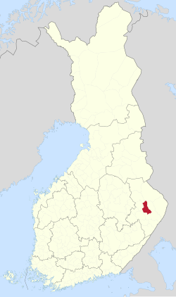
 Location of Kontiolahti in Finland | |
| Coordinates: 62°46′N 029°51′E / 62.767°N 29.850°E | |
| Country | |
| Region | North Karelia |
| Sub-region | Joensuu |
| Charter | 1873 |
| Government | |
| • Municipal manager | Jere Penttilä |
| Area (2018-01-01)[1] | |
• Total | 1,029.82 km2 (397.62 sq mi) |
| • Land | 799.82 km2 (308.81 sq mi) |
| • Water | 230.1 km2 (88.8 sq mi) |
| • Rank | 101st largest in Finland |
| Population (2024-10-31)[2] | |
• Total | 15,048 |
| • Rank | 74th largest in Finland |
| • Density | 18.81/km2 (48.7/sq mi) |
| Population by native language | |
| • Finnish | 97.6% (official) |
| • Swedish | 0.1% |
| • Others | 2.3% |
| Population by age | |
| • 0 to 14 | 21.1% |
| • 15 to 64 | 61% |
| • 65 or older | 17.9% |
| Time zone | UTC+02:00 (EET) |
| • Summer (DST) | UTC+03:00 (EEST) |
| Website | www.kontiolahti.fi |
Kontiolahti (Swedish: Kontiolax; literally meaning "bear bay") is a municipality in Finland. It is located in the North Karelia region, about 20 kilometres (12 mi) north of Joensuu. The municipality has a population of 15,048 (31 October 2024)[2] and covers an area of 1,029.82 square kilometres (397.62 sq mi) of which 230.1 km2 (88.8 sq mi) is water.[1] The population density is 18.81 inhabitants per square kilometre (48.7/sq mi). Neighbouring municipalities are Joensuu, Juuka, Lieksa, Liperi and Polvijärvi. The municipality is unilingually Finnish.
The coat of arms of the municipality is a canting arms; the log driving pike pole, which the bear carries in the picture, refers to the importance of forestry in the region's economy. The coat of arms was designed by Aarno Liuksiala and approved by the Kontiolahti Municipal Council at its meeting on December 8, 1952. The coat of arms was approved for use by the Ministry of the Interior on February 27, 1953.[5][6]
Kontiolahti hosted the Biathlon World Championships in 1990, 1999 and 2015.[7]
History
[edit]Kontiolahti originally belonged to the parish of Liperi. It became an independent municipality in 1873. The flood nuisance of Lake Höytiäinen and the desire for water abandonment inspired residents to try to build a canal to lower the water level, but the dam broke uncontrollably in 1859, and the landscape changed dramatically.[8] After World War II, the Ruskeala's migrants were stationed in Kontiolahti.
Geography
[edit]
Kontiolahti has 183 lakes, and water bodies cover 22.3 percent (230 km2) of the municipality's surface area. The largest of them are Lake Höytiäinen, Lake Kangasvesi and Lake Herajärvi.[9] There are 11 Natura sites in all or part of Kontiolahti: Teerisaari-Sisuslahti, Soikkeli Forest, Pöllönvaara-Kruununkangas, Paihola Forest, Kolvananuuro and surrounding areas, Koli National Park, Jouhteninen, Huurunlampi-Sammakkolampi-Huurunrinne and Huuhkajanvaara.[10]
Villages
[edit]Transport
[edit]Joensuu Region's Public Transport (Joensuun seudun joukkoliikenne; JOJO) is responsible for local and school traffic in the Kontiolahti area.[12] Kontiolahti also has a railway station,[13] which, however, no longer has passenger traffic. Highway 6 passes through the municipality.[14][11]
Culture
[edit]Libraries
[edit]Municipal library services are provided by the Kontiolahti Library, the Lehmo Library, and Runo-Antti, the bookmobile of Kontiolahti and Eno.[15][16][17][18]
Food
[edit]In the 1980s, Kontiolahti's parish dishes were named "shoemaker's roast" (suutarinpaisti) and stockfish soup.[19]
Notable people
[edit]- Tero Mustonen (born 1976 or 1977), environmental leader, scholar, scientist, and fisherman
- Jukka Nevalainen (born 1978), former drummer of Nightwish
- Markku Pölönen (born 1957), film director, screenwriter, editor and owner of film production company Suomen Filmiteollisuus
- Antti Puhakka (1816–1893), national romantic poet
See also
[edit]References
[edit]- ^ a b "Area of Finnish Municipalities 1.1.2018" (PDF). National Land Survey of Finland. Retrieved 30 January 2018.
- ^ a b c "Finland's preliminary population figure was 5,635,560 at the end of October 2024". Population structure. Statistics Finland. 19 November 2024. ISSN 1797-5395. Retrieved 22 November 2024.
- ^ "Population according to age (1-year) and sex by area and the regional division of each statistical reference year, 2003–2020". StatFin. Statistics Finland. Retrieved 2 May 2021.
- ^ a b "Luettelo kuntien ja seurakuntien tuloveroprosenteista vuonna 2023". Tax Administration of Finland. 14 November 2022. Retrieved 7 May 2023.
- ^ Suomen kunnallisvaakunat (in Finnish). Suomen Kunnallisliitto. 1982. p. 139. ISBN 951-773-085-3.
- ^ "Sisäasiainministeriön vahvistamat kaupunkien, kauppaloiden ja kuntien vaakunat 1949-1995 I:10 Kontiolahti". Kansallisarkiston digitaaliarkisto (in Finnish). Retrieved 8 August 2021.
- ^ ""Kontiolahden Urheilijat" [Kontiolahti Sports Club]. Kontiolahti: Kontiolahden Urheilijat r.y. Archived from the original on 12 November 2013. Retrieved 17 November 2013.
- ^ "Historian Havinaa" (in Finnish). Kontiolahti. Archived from the original on 14 December 2017. Retrieved 8 August 2021.
- ^ Kontiolahden järvet – Järviwiki (in Finnish)
- ^ Tutustu Natura 2000 -kohteisiin kunnittain – Ympäristö.fi (in Finnish)
- ^ a b Kylät Pohjois-Karjalassa – Kylät.fi (in Finnish)
- ^ JOJO – Official Site (in English)
- ^ YLE: Koti rautatien varrella (in Finnish)
- ^ Maantien 15716 kevyen liikenteen väylä välillä Urheilukentäntie – Tuppihaantie, Kontiolahti – Väylä (in Finnish)
- ^ "Kontiolahden kirjasto – Ota yhteyttä". kirjastot.fi (in Finnish). Retrieved 8 August 2021.
- ^ "Kontiolahden kirjasto" (in Finnish). Vaara-kirjastot. Retrieved 8 August 2021.
- ^ "Lehmon kirjasto" (in Finnish). Vaara-kirjastot. Retrieved 8 August 2021.
- ^ "Kontiolahden ja Enon kirjastoauto". kirjastot.fi (in Finnish). Archived from the original on 21 May 2021. Retrieved 8 August 2021.
- ^ Jaakko Kolmonen (1988). Kotomaamme ruoka-aitta: Suomen, Karjalan ja Petsamon pitäjäruoat (in Finnish). Helsinki: Patakolmonen. pp. 122–123. ISBN 951-96047-3-1.
External links
[edit] Media related to Kontiolahti at Wikimedia Commons
- Municipality of Kontiolahti – Official website, finnish, english, germany and russian
- Sirnihta Holiday Villa's


